Click Here for Google Map

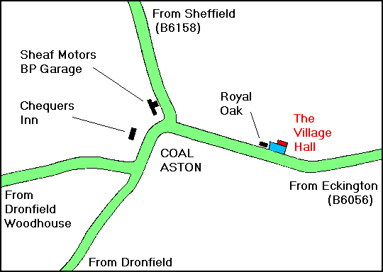
Coal Aston is located in North East Derbyshire, approximately half way between Chesterfield and Sheffield. As shown on the above map, the Village Hall can be approached via three main routes:
Travel past the Chequers Inn and then bear right at the mini-roundabout. After
300m, look out for the Royal Oak Public House on your left. Turn left into the Village
Hall car park just after the Royal Oak.
Travel towards Coal Aston on the B6056 Eckington Road. After entering the 30mph speed
restriction signs at the village boundary, look out for the Royal Oak Public House on the
right after approximately 150m. Turn right into the Village Hall car park just before the
Royal Oak.
Travel towards Coal Aston on the B6158 Dyche Lane. After passing the Sheaf Motors BP
garage, turn left at the mini-roundabout. After 300m, look out for the Royal Oak Public
House on your left. Turn left into the Village Hall car park just after the Royal Oak.
From Dronfield Woodhouse or Dronfield (via Holmley Lane or Green Lane)
From Eckington/Troway/Apperknowle/Marsh Lane
From Sheffield